Model Building Workflow
Imagine you are trying to find a hidden treasure chest buried in a massive, overgrown forest. You cannot dig up the entire forest, so you look for clues like old maps or strange mounds of dirt to narrow your search area. Archaeologists use this same logic when they build models to find ancient sites. They do not guess where to look, but instead they use data to build a map of high-probability zones. By studying past human behavior, they can predict where people once lived.
Designing the Data Framework
When researchers begin building a model, they must first gather reliable environmental data layers to serve as their foundation. These layers include slope, water proximity, and soil type, which all influence where people chose to settle in the past. Think of these data layers like ingredients in a recipe for a cake. If you leave out the flour, the cake will not form, just as a model fails if it lacks key geographic variables. The researcher must clean this data to ensure the information is accurate and ready for analysis.
Key term: Predictive Modeling — the process of using statistical patterns from known sites to forecast the locations of unknown archaeological resources.
Once the data is cleaned, the team must decide which variables carry the most weight for their specific study area. For example, in a desert region, the distance to a water source is likely the most important factor for human survival. By assigning higher values to these critical variables, the model becomes much more effective at highlighting likely spots. This process of weighting allows the researcher to tailor the model to the specific needs of the ancient culture being studied.
Executing the Modeling Process
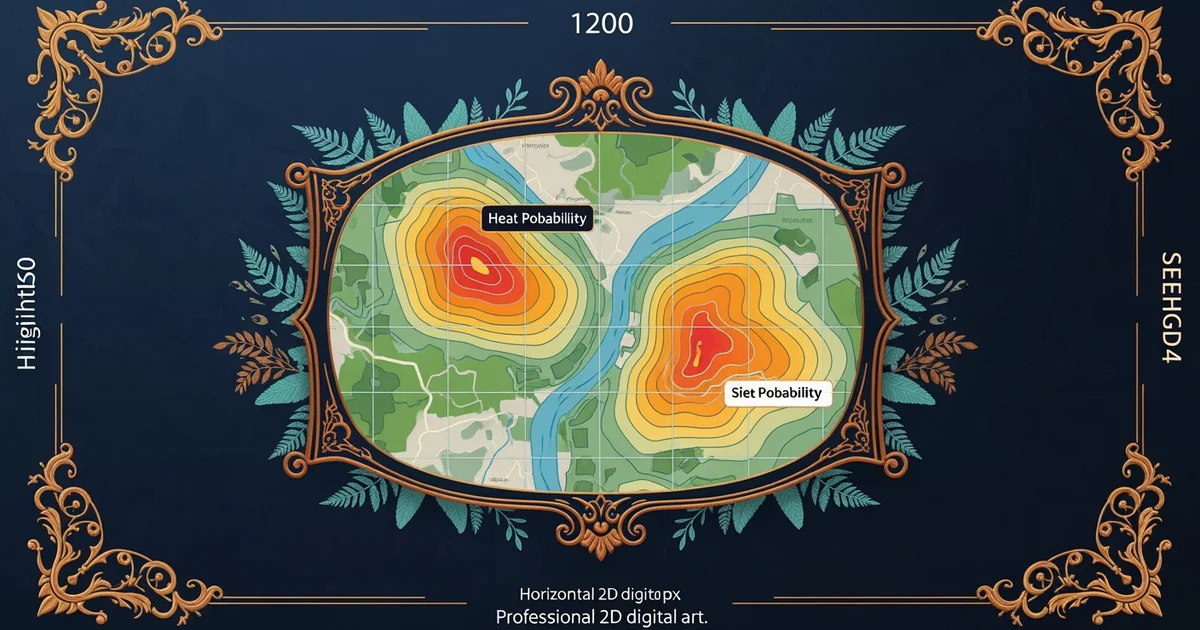
After the variables are weighted, the modeler runs a series of calculations to generate a probability map for the entire region. This map acts like a heat map, where brighter colors show areas with a high chance of containing archaeological remains. Researchers then take this map into the field to verify the results through physical survey work. If the model predicts a site exists in a specific valley, the team goes there to see if they find pottery or stone tools.
The workflow follows a logical, step-by-step path to ensure the results remain consistent and easy to test:
- Data Collection: Gather geographic information like elevation and vegetation cover to build the base map for the study area.
- Variable Weighting: Assign numerical values to factors based on how much they influenced past human movement and settlement choices.
- Map Generation: Use computer software to combine all layers into a single visual output that identifies high-probability zones.
- Field Verification: Conduct ground surveys in predicted areas to confirm the presence or absence of actual human artifacts.
- Model Refinement: Update the original parameters based on new field findings to make future predictions even more accurate.
When the team finishes the field check, they often find that the model needs slight adjustments to improve its future performance. This feedback loop is essential because it turns a static map into a living tool that learns from new discoveries. If the model missed a site, the researchers analyze why that location was overlooked and adjust their weighting system. This iterative process ensures that the model becomes sharper and more reliable with every single project cycle. By repeating these steps, archaeologists can cover vast landscapes that would otherwise remain completely unexplored.
| Stage | Primary Goal | Action Taken |
|---|---|---|
| Input | Data Prep | Cleaning raw geographic files |
| Logic | Weighting | Assigning importance to variables |
| Output | Mapping | Creating the probability heat map |
| Review | Validation | Testing predictions in the field |
This table shows how each stage moves from raw information toward a final, actionable map for field crews. Without this structured approach, the search for sites would be purely random and inefficient for the research team. By following this workflow, archaeologists maximize their time and resources while uncovering the hidden history of past human civilizations across diverse landscapes.
Predictive modeling creates a structured path for discovery by turning environmental data into a map that guides researchers toward the most likely locations of ancient human activity.
But now that the model is built, how do we ensure the data from different sources can actually work together correctly?
Want this with sources you can check?
Premium Learning Paths for History & Archaeology are researched against open-access libraries — PubMed, arXiv, government databases, and more — with their distinctive claims cited to real sources and independently checked.
See what Premium includes