Historical Context Analysis
Imagine you are trying to find a lost set of keys in a large, messy house. You would not just search every single square inch of the floor at random. Instead, you would think about where you were, what you did, and which rooms you visited earlier that day. This process of using past clues to narrow your search is exactly how archaeologists use Historical Context Analysis to find hidden sites. By linking old maps, diaries, and records to the physical landscape, they transform a vast search area into a focused list of high-probability locations.
Integrating Textual Records with Spatial Data
Archaeologists rely on written records to provide the "who" and "when" for a specific region. These documents might include colonial land grants, early military logs, or even local folklore passed down through generations. While these texts are not maps, they contain geographic clues that act like breadcrumbs leading to a destination. To use this information, researchers must translate vague descriptions into coordinates that fit onto a digital map. This step is crucial because it bridges the gap between human memory and the rigid geometry of a modern geographic information system.
Key term: Historical Context Analysis — the process of evaluating past human activity by combining written records with environmental data to predict where archaeological sites exist.
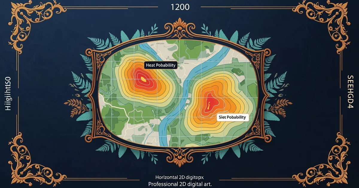
When you integrate these texts, you are essentially building a mental map of past activity. Think of this process like planning a road trip using a travel guide written fifty years ago. You know the main highway still exists, but you must account for new bypasses and changed landmarks. By overlaying the old records onto current satellite imagery, you can identify spots where historical events likely occurred. This method prevents wasted time by ensuring that field crews only dig in areas where the historical evidence aligns with the physical terrain.
The Logic of Predictive Mapping
Once you have linked your texts to specific spots, you must determine if those areas are still viable for discovery. Historical records often mention features that have since vanished or changed beyond recognition. For instance, a river mentioned in a 1700s journal might have shifted its course several times over the last few centuries. You must evaluate these changes to see if the site remains buried under modern construction or if it has been washed away by erosion. This logic helps you filter out low-probability zones before you ever pick up a shovel.
To manage this complexity, researchers often organize their data into a simple comparison framework to decide which sites deserve the most attention during their field surveys:
| Data Type | Primary Function | Potential Limitation |
|---|---|---|
| Tax Records | Identifies land ownership | Vague boundary descriptions |
| Military Logs | Tracks troop movements | Often lacks specific landmarks |
| Oral History | Highlights local legends | Subjective and hard to verify |
Using this table, you can weigh the value of each information source against its typical weaknesses. If a tax record says a farm existed near a creek, you know the area is promising, but you must cross-reference it with geological maps to find where that creek actually flowed back then. This systematic approach turns historical guesswork into a reliable scientific strategy for discovery. By combining these varied data points, you create a stronger model that accounts for the messy nature of human history and the changing face of the earth.
Historical context analysis turns vague written clues into precise geographic targets by aligning past records with modern physical landscapes.
The next Station introduces Model Building Workflow, which determines how these combined data sets are processed into final predictive maps.